Why Streets Meet at Such Different Angles
Why streets meet at different angles becomes easier to read when you compare slopes, older routes, and later grids on a map, block by block.
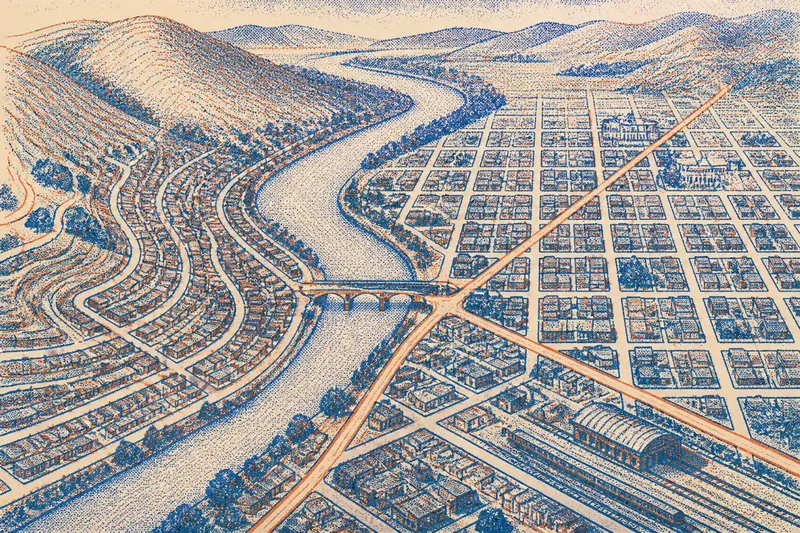
On a phone map, one street may run straight toward the river while the next cuts across it, and a third bends around a hill. Why streets meet at different angles is often easier to understand by comparing their lines with the ground and with routes that were already there. An intersection preserves clues about how a city was assembled, though it does not explain every decision.
Begin with the shape of the ground
A grid looks effortless on a flat page. On a hillside, its straight lines may climb steeply, cross drainage channels, or run along contours instead. The street pattern can record compromises between a convenient route and the slope beneath it.
Open a topographic layer in Google Maps or another mapping app, if one is available, and compare contour lines with the street map. Closely spaced contours indicate a sharper slope; broad, widely spaced contours suggest gentler ground. A road that tracks along a contour may bend around a hill, while one crossing several contours may climb more directly.
Look for a pattern, not a single bend. One angled intersection could reflect an ordinary property boundary or a later design choice. A series of streets that curve in parallel, or converge toward a pass between hills, offers a stronger clue that terrain shaped movement.
- Notice whether long streets climb, descend, or stay at roughly the same elevation. If they follow a slope, compare the pattern with contours; if not, consider other influences such as property lines.
- Check for switchbacks or repeated bends where a direct route would face a steep slope. If the bends track the hillside, terrain may help explain them; if they do not, inspect nearby boundaries or infrastructure.
- Trace low ground and drainage corridors. If several streets skirt a valley or cross it at the same points, water or terrain may have shaped access; otherwise, look for another barrier or route connection.
- Compare the same route at different zoom levels. If a small jog disappears into a broader alignment, treat it as a minor offset; if it persists across blocks, examine it as a possible transition.
Terrain does not dictate one inevitable street plan. Builders can cut into slopes, bridge low ground, or choose another route. The useful question is narrower: does the street pattern make more sense when read against the land?
Follow routes that the grid did not erase
Before a district acquired a regular layout, people and vehicles may already have traveled between a landing, market, bridge, station, or settlement. A later grid can overlay these routes without removing them. An older path may survive as a diagonal avenue, a kink between blocks, or a street that changes direction where it meets a newer pattern.
On a map, identify a diagonal that continues for several blocks and ask what it connects. Does it point toward a river crossing or a rail station? Does it join two neighborhoods more directly than the surrounding streets? Its endpoints can suggest its role, though they cannot establish its age on their own.
Then compare the blocks on either side. If rectangular blocks meet a diagonal corridor at changing angles, the street may have been retained as a boundary or through-route while the surrounding land was replanned. If several diagonals meet near one crossing, the place may have served as a connector before nearby streets took their present form.
Historic maps can help distinguish a surviving route from a visual coincidence. Local libraries, city archives, and historical map collections often provide scanned plans or aerial images. Compare stable features such as a river bend, rail line, or large public building rather than relying only on street names, which may change or move.
Read the seams between street plans
Different street patterns often touch rather than blend. A tight grid can stop at a broad diagonal; curving streets can end at a straight avenue; a regular plan can narrow where it meets an older settlement. These seams show where one organizing idea gives way to another.
Follow a seam for more than one block. A single offset may come from a property line or an intersection designed to slow traffic. A recurring edge—where block shapes change, streets stop aligning, and lot lines shift together—suggests that the areas were laid out under different conditions or plans.
Branching patterns deserve the same care. Several streets radiating from a center can reflect a planned focal point, a route junction, or a path network that spread outward over time. Look for evidence around the hub: a bridge, station, civic building, or former market site may help explain why routes gathered there. Do not assume every fan-shaped pattern was planned as a whole.
Street width can add context, but it is not a reliable clock by itself. A broad road may be a later improvement, an older main route, or a corridor reserved for a particular purpose. Use width alongside block shape, alignment, and map layers instead of treating it as proof.
Compare street angles without overreading them
A map comparison works best when the views are consistent. Keep the same scale and orientation as you compare districts, and use a street map alongside terrain shading or a topographic layer. If you switch between a simplified map and satellite imagery, note what each reveals: one clarifies alignments, while the other can show slopes, waterways, and large barriers.
Imagine you are studying an invented pair of districts on opposite sides of a river. The starting map shows streets parallel to the bank in one district, a diagonal road leading to a bridge, and a grid beyond it. First, compare the parallel streets with the shoreline and contours; they track the river, so the land may help explain their alignment. Next, follow the diagonal past the bridge; it continues through the grid, suggesting a direct crossing route was retained. Finally, compare an older map with the current one, using the river bend as a fixed reference; if the diagonal appears on both, it predates at least part of the surrounding grid. The resulting reading is that the river shaped one set of alignments and the crossing preserved a connection, while the map alone cannot establish who made each choice or why.
Use this sequence when comparing a small area:
- Choose a small area. Include a few blocks on each side of the pattern so you can see whether an angle repeats. If it does, examine it as a broader alignment; if not, treat it as a local feature.
- Trace the main lines. Follow the longest streets first, then note where they bend, branch, or stop. If a line continues across blocks, look for what it connects; if it ends, inspect the nearby boundary or barrier.
- Add the land. Compare the streets with contours, ridges, valleys, shorelines, and waterways. If the geometry tracks a landform, terrain is a plausible influence; if it does not, keep other explanations open.
- Look for older connections. Check whether a diagonal links likely crossing points or continues through a later grid. If it does, compare historic maps; if it does not, consider a property boundary or later route.
- Find the transition. Mark where block shapes or street directions change together. If several features shift at one edge, treat it as a possible seam between plans; if only one corner differs, avoid drawing a district-wide conclusion.
- Keep more than one explanation open. Consider terrain, earlier routes, property boundaries, and later planning. If several explanations fit, describe the visible pattern and name the alternatives rather than choosing one without evidence.
What can street angles tell you?
Why do diagonal streets cut across a grid?
A diagonal may preserve an earlier route, connect important destinations, or respond to terrain that does not fit the grid. Trace it beyond the blocks in view and compare its direction with crossings, slopes, and district edges.
Do streets that meet at right angles always belong to a planned grid?
Not necessarily. Local blocks can look regular even when they developed in stages, and a planned grid may be altered by land boundaries or barriers. Look for repeated block shapes and consistent alignments across a broader area before calling it a grid.
How can a map suggest that a street is older than its neighbors?
A street that crosses several later alignments, changes direction at a district boundary, or connects longstanding travel points may have been retained from an earlier route. Historic maps can add support, but a present-day shape alone cannot date a street.
Can terrain explain every bend?
No. Property lines, infrastructure, planning choices, and later changes can also produce bends. Terrain is more convincing as an explanation when the pattern repeats and corresponds with slopes, valleys, or other features on the ground.
Keep the explanation proportional to the evidence
When two patterns meet, several causes may overlap. A route could follow a valley, serve a bridge, and remain in place when a grid was added around it. Distinguish what the map shows from what you infer: “the street follows the valley” describes an observable relationship; “it was built for this reason” requires more evidence.
For a closer comparison, place an older map beside a current one and align stable features such as waterways or rail corridors. Watch which streets persist, which appear later, and where block boundaries shift. Map labels and historical records may clarify the sequence, but the geometry alone can still show where a city’s plans meet.
Why streets meet at different angles has no single answer for every corner. Read the repeated lines, the land beneath them, and the seams between districts, then let the evidence set the limits of your conclusion. On a walk, notice whether the same transition appears in building setbacks or sidewalk direction; that street-level detail can help you locate the seam on the map.